Planning District
What is a planning district?
A relatively new concept in Los Angeles, planning districts are geographically bound areas that are ineligible for historic designation, but merit special consideration in local planning efforts.
The unique character of these districts is often defined by consistent building heights, massing, setbacks, and street trees, and they may share a sense of history.
What do planning districts mean for me?
The City of L.A. identified numerous planning districts through SurveyLA, its comprehensive historic resources survey, but has not yet established rules and guidelines for managing these neighborhoods.
If you are concerned about the loss of character of an identified planning district in your neighborhood, there are a number of ways for you to press for new conservation tools to enhance, rather than erase this sense of place. The right avenue will depend on your long-term goals and the existing fabric of your community.
re:code LA, the City's multi-year update to its zoning code, will establish new context sensitive zones based on building forms, not uses. Participating in public workshops while the code is being developed will help you understand the new menu of options when your neighborhood's Community Plan is being revised with the updated code.
With further analysis and field work, some planning districts could become eligible for Historic Preservation Overlay Zone (HPOZ) designation in the future.
Although this tool does not yet exist, planning districts would also be excellent candidates for conservation district status.
Background
The City of Los Angeles recently completed an ambitious citywide historic resources survey, an initiative known as "SurveyLA." With funding from the J. Paul Getty Trust, fieldwork occurred between 2010 and 2016. The Office of Historic Resources is responsible for administering the survey.
In addition to identifying potential individual historic resources and historic districts, SurveyLA has evaluated areas known as "planning districts." While not necessarily eligible for historic designation, planning districts are discrete neighborhoods that warrant special consideration in planning and land use decisions.
Planning districts may include residential clusters, commercial corridors, industrial areas, and unique streetscapes.
They often reveal underlying patterns of development, as well as consistent design and landscaping, that impart a discernable sense of place. Often, planning districts are home to collections of "background buildings," which are modest, small-scale yet distinctive structures that contribute to the character of their neighborhoods.
The identified Sunset Junction Planning District in Silver Lake is a good example of a commercial planning district. The area is associated with early twentieth century commercial and streetcar development on Sunset and Santa Monica Boulevards, as well as postwar LGBTQ and Latinx history.
According to SurveyLA, many of the individual properties in the district have been altered and no longer retain integrity from their period of significance. While the district does not meet eligibility requirements for historic designation, it does maintain consistent massing and scale, and it continues to function as a neighborhood commercial center.
The Entertainment Industry Support Services Planning District—generally bounded by Sunset Boulevard, Melrose Avenue, N. La Brea Avenue, and Vine Street in Hollywood—is an excellent example of an industrial planning district.
Located in Hollywood, this neighborhood was once the largest concentration of motion picture-related support industries, such as film processing, storage, camera equipment vendors, and office space.
Today, however, the area no longer retains integrity as an historic district due to alterations, teardowns and parking lot construction. Nevertheless, it still contributes to Hollywood's historic identity as the center of the motion picture industry.
Other planning districts highlight significant streetscapes or single-family neighborhoods.
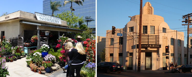
Located west of Sawtelle Boulevard in West Los Angeles, the Japanese Gardens Planning District features foliage native to Japan—such as Japanese maple, Japanese azalea, and Japanese camellia—and incorporates design elements such as lanterns, statuary, and stepping stones.
While the integrity of the original gardens varies among properties, together they reflect the influence of the Japanese American agricultural community in Sawtelle prior to World War II, as well as patterns of settlement and acculturation after the war.
The Office of Historic Resources has documented many other planning districts in nearly all of the City's thirty five Community Plan Areas. They suggest, with further research and analysis, that some could be potential HPOZs in the future, while others should be given special consideration in long-range planning efforts, such as Community Plan updates and other policy documents.
In the future, planning districts could benefit from new zoning tools designed to enhance existing neighborhood character, such as conservation district classifications.